Seswantšho:LocationMauritius.png
Gago resolution ya go feta mo.
LocationMauritius.png (248 × 117 pixel, bogolo ba faele: 3 KB, Mohuta wa MIME: image/png)

|
This locator map image could be re-created using vector graphics as an SVG file. This has several advantages; see Commons:Media for cleanup for more information. If an SVG form of this image is available, please upload it and afterwards replace this template with
{{vector version available|new image name}}.
It is recommended to name the SVG file “LocationMauritius.svg”—then the template Vector version available (or Vva) does not need the new image name parameter. |
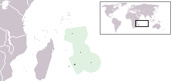
Location map for the Mauritius.
Originally created for English Wikipedia by Vardion.
| |
This work has been released into the public domain by its author, Vardion, at the English Wikipedia project. This applies worldwide. In case this is not legally possible: |
Histori ya faele
Pinyeletša go letšatšikgwedi/nako go bona faela ka tsela yeo ebego e le ka gona nakong yeo.
| LetšatšiKgwedi/Nako | Nkgogorupo-Nala | Bogolo | Mošomiši | Comment | |
|---|---|---|---|---|---|
| bjale | 03:28, 16 Pherekgong 2012 | | 248 × 117 (3 KB) | Ras67 | cropped |
| 16:02, 1 Phupu 2008 |  | 250 × 119 (5 KB) | Panos84 | {{Information= Location of the island nation of Mauritius and its exclusive economic zone. |Source= Own work |Date= 01 June 2008 |Author= Panos84 (Panagiotis V. Lazaridis) }} | |
| 04:55, 5 Hlakola 2008 |  | 250 × 119 (5 KB) | Panos84 | Location of the island nation of Mauritius and its exclusive economic zone. | |
| 20:32, 12 Manthole 2004 |  | 250 × 115 (5 KB) | EugeneZelenko | Location map for the Mauritius.<br/>Originally created for English Wikipedia by Vardion.<br/>{{PD}}<br/>Category:Country locator maps |
Tirišo ya Faele
Letlakala le ke latelago a hlomaganya go faele ye:
Global file usage
The following other wikis use this file:
- Usage on als.wikipedia.org
- Usage on am.wikipedia.org
- Usage on ar.wikipedia.org
- Usage on arz.wikipedia.org
- Usage on ban.wikipedia.org
- Usage on be-tarask.wikipedia.org
- Usage on be.wikipedia.org
- Usage on bg.wikipedia.org
- Usage on bjn.wikipedia.org
- Usage on bo.wikipedia.org
- Usage on bpy.wikipedia.org
- Usage on bs.wikipedia.org
- Usage on ca.wikipedia.org
- Usage on cv.wikipedia.org
- Usage on da.wikipedia.org
- Usage on de.wiktionary.org
- Usage on en.wikipedia.org
- User:DanielZM/test
- User:Chris huh/List of African countries
- Portal:Africa/Countries/Selected country
- Portal:Africa/Countries/Selected country/33
- Outline of Mauritius
- List of Mauritius-related topics
- Category:Roman Catholic dioceses in Mauritius
- Wikipedia:Graphics Lab/Map workshop/Archive/Nov 2009
- Wikipedia:Graphics Lab/Map workshop/Archive/Jan 2010
- List of non-marine molluscs of Mauritius
- List of moths of Mauritius
- List of butterflies of Mauritius
- Usage on en.wikinews.org
- Usage on en.wiktionary.org
- Usage on eo.wikipedia.org
- Usage on eo.wiktionary.org
- Usage on es.wikipedia.org
- Usage on es.wikinews.org
- Usage on et.wiktionary.org
- Usage on ext.wikipedia.org
- Usage on fa.wikipedia.org
- Usage on fiu-vro.wikipedia.org
View more global usage of this file.