Seswantšho:Sri Lanka - Location Map (2011) - LKA - UNOCHA.svg

''resolution'' ya gofella (SVG faele, nominally 254 × 254 pixels, bogolo ba faele: 512 KB)
_-_LKA_-_UNOCHA.svg)
Kakaretšo
| Description |
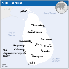
English: Locator map of Sri Lanka. |
| Letšatšikgwedi | |
| Mothopo |
English: Sri Lanka Locator Map (ReliefWeb), ESRI, UNCS, Gov’t. of Sri Lanka |
| Mongwadi | |
| SVG genesis |
Laesense
- You are free:
- to share – to copy, distribute and transmit the work
- to remix – to adapt the work
- Under the following conditions:
- attribution – You must give appropriate credit, provide a link to the license, and indicate if changes were made. You may do so in any reasonable manner, but not in any way that suggests the licensor endorses you or your use.
 This map is part of a collection of 216 free country maps, created by the UN Office for the Coordination of Humanitarian Affairs (OCHA), to be used in print, web or broadcast products.
The ReliefWeb Location Maps released here are maps that highlight a country, its capital, major populated places and the surrounding regions. Attribution Requirements
Using the map without modifications: ensure that the sources and the disclaimer are below the map. Credit as follows: "Credit: OCHA". For use with alteration: remove the OCHA logo and disclaimer following any modification to the map, but keep the data sources as mentioned below the map. Credit the modified map as follows: "Based on OCHA map". You are responsible for the content of your map. We are keen to receive your feedback and hear how you used OCHA's maps. We would be grateful if you would notify us by e-mail and share your work with us. UN Disclaimer
The designations employed and the presentation of material of this map do not imply the expression of any opinion whatsoever on the part of the Secretariat of the United Nations concerning the legal status of any country, territory, city or area or of its authorities or concerning the delimitation of its frontiers or boundaries. |
| Annotations | This image is annotated: View the annotations at Commons |
Histori ya faele
Pinyeletša go letšatšikgwedi/nako go bona faela ka tsela yeo ebego e le ka gona nakong yeo.
| LetšatšiKgwedi/Nako | Nkgogorupo-Nala | Bogolo | Mošomiši | Comment | |
|---|---|---|---|---|---|
| bjale | 11:56, 26 Dibatsela 2015 | | 254 × 254 (512 KB) | Chamath456 | remove logo |
| 10:44, 3 Diphalane 2015 |  | 254 × 254 (546 KB) | Lyndonbaines | Reverted to version as of 04:36, 21 April 2014 (UTC) | |
| 10:44, 3 Diphalane 2015 |  | 1,000 × 1,000 (536 KB) | Lyndonbaines | Reverted to version as of 03:10, 11 December 2014 (UTC) | |
| 08:32, 9 Phupu 2015 |  | 1,000 × 1,000 (550 KB) | Chamath456 | correction | |
| 05:10, 11 Manthole 2014 |  | 1,000 × 1,000 (536 KB) | Nafsadh | remove logo and use conventional colors | |
| 06:36, 21 Moranang 2014 |  | 254 × 254 (546 KB) | UN OCHA maps bot | == {{int:filedesc}} == {{Information |description={{en|1=Locator map of Sri Lanka.}} |date=2011 |source={{en|1=[http://reliefweb.int/map/sri-lanka/sri-lanka-location-map-2011 Sri Lanka Locator Map (ReliefWeb)]}} |author={{en|1=[[w:en... |
Tirišo ya Faele
Letlakala le ke latelago a hlomaganya go faele ye:
Global file usage
The following other wikis use this file:
- Usage on azb.wikipedia.org
- Usage on az.wiktionary.org
- Usage on dty.wikipedia.org
- Usage on en.wikipedia.org
- Usage on id.wikipedia.org
- Usage on ilo.wikipedia.org
- Usage on incubator.wikimedia.org
- Usage on io.wikipedia.org
- Usage on pap.wikipedia.org
- Usage on pt.wikipedia.org
- Usage on sco.wikipedia.org
- Usage on sd.wikipedia.org
- Usage on si.wikipedia.org
- Usage on sl.wikipedia.org
- Usage on ta.wikipedia.org
- Usage on tcy.wikipedia.org
_-_LKA_-_UNOCHA.svg)