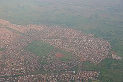
Vosloorus
Vosloorus ke toropokgolo, e borwa ka Boksburg le bohlabela ka Katlehong wa Ekurhuleni Metropolitan Municipality go feta porofense Gauteng ka moka Afrika Borwa.
| Vosloorus | |
|---|---|
 Aerial view of Vosloorus | |
| Coordinates: 26°21′30″S 28°12′27″E / 26.35833°S 28.20750°E | |
| Naga | Afrika Borwa |
| Porofense | Gauteng |
| Mmušôselegae | Ekurhuleni Metropolitan Municipality|Ekurhuleni |
| Hlômile | 1963 |
| Sekgôba[1] | |
| • Total | 32.10 km2 (12.39 sq mi) |
| Setšhaba (2011)[1] | |
| • Total | 163,216 |
| • Phitlaganyo | 5,100/km2 (13,000/sq mi) |
| Dipersente tša merafe (2011)[1] | |
| • Bathobaso | 99.3% |
| • Bammala | 0.3% |
| • MaIndia | 0.2% |
| • Makgowa | 0.1% |
| • Šele | 0.1% |
| Dipolelo tša ntlha (2011)[1] | |
| • Sezulu | 46.8% |
| • Sesotho | 18.0% |
| • Sethosa | 8.2% |
| • Sepedi | 7.3% |
| • Šele | 19.7% |
| Nomoro ya poso (Setarata) | 1475 |
| Nomoro ya poso (Lepokisi) | 1486 |
It was established in 1963 when Black Africans were removed from Stirtonville[2]
Vosloorus e 24 km borwa ka Johannesburg.
Ditšhupetšo
lokiša- ↑ 1.0 1.1 1.2 1.3 "Main Place Vosloorus". Census 2011.
- ↑ Harry Mashabela (1988). Townships of the PWV. South African Institute of Race Relations. p. 169. ISBN 0-86982-343-4.
