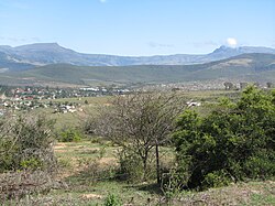
Keiskammahoek
Keiskammahoek ke toropo go feta Amahlathi Mmusogae, Mmasepala Setereke tša Amathole wa porofense Kapa Bohlabela (Eastern Cape) ka moka Afrika Borwa.
| Keiskammahoek | |
|---|---|
 View of Keiskammahoek from the hill | |
| Coordinates: 32°41′S 27°09′E / 32.683°S 27.150°E | |
| Naga | Afrika Borwa |
| Porofense | Kapa Bohlabela |
| Mmasepala wa Selete | Amathole |
| Mmušôselegae | Amahlathi |
| Sekgôba[1] | |
| • Total | 15.67 km2 (6.05 sq mi) |
| Elevation | 670 m (2,200 ft) |
| Setšhaba (2011)[1] | |
| • Total | 4,429 |
| • Phitlaganyo | 280/km2 (730/sq mi) |
| Dipersente tša merafe (2011)[1] | |
| • Bathobaso | 97.1% |
| • Bammala | 1.4% |
| • MaIndia | 0.2% |
| • Makgowa | 0.3% |
| • Šele | 1.0% |
| Dipolelo tša ntlha (2011)[1] | |
| • Sethosa | 94.6% |
| • Afrikaans | 1.8% |
| • Seisimane | 1.1% |
| • Šele | 2.6% |
| Nomoro ya poso (Setarata) | 5670 |
| Nomoro ya poso (Lepokisi) | 5670 |
| Khoutu ya lefelo | 040 |

Ditšhupetšo
lokiša- ↑ 1.0 1.1 1.2 1.3 "Main Place Keiskammahoek". Census 2011.
